


20181017 Le Bourguet Robion

Sugg
User
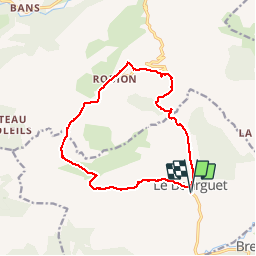

Length
15 km

Max alt
1158 m

Uphill gradient
381 m
Km-Effort
20 km

Min alt
841 m

Downhill gradient
381 m
Boucle
Yes
Creation date :
2019-03-22 16:57:41.572
Updated on :
2019-03-22 16:57:41.699
5h41
Difficulty : Easy

FREE GPS app for hiking
 SityTrail
IGN / Geographical institutes
SityTrail Plus
The world is yours!
About
Trail Walking of 15 km to be discovered at Provence-Alpes-Côte d'Azur, Var, Le Bourguet. This trail is proposed by Sugg.
Description
Rando RF guidée par Pierre
Photos


Positioning
Country:
France
Region :
Provence-Alpes-Côte d'Azur
Department/Province :
Var
Municipality :
Le Bourguet
Location:
Unknown
Start:(Dec)
Start:(UTM)
300333 ; 4850764 (32T) N.
Comments